We were up at 7:30 a.m. and repeated our breakfast routine from yesterday.
As we were getting ready to leave the inn, we looked outside and it was, of course, raining!
Based on the posted forecast (which the front desk staff update regularly), we decided to head for the coast and take a scenic drive rather than attempting another hike, although we did hold onto a vague scrap of hope that the clouds would thin out in the afternoon and we just
might be able to squeeze in a hike.
We headed first to the Spar grocery store (a German chain, ironically) in Glencoe village to buy a few lunch items. Then we stopped at the Glencoe Visitor Center, which is a brand-new eco-friendly building, but didn’t see the exhibit since it cost £5 each and we didn’t want to linger too long. We did visit the very nice gift shop, which has an amazing collection of Scottish history books and novels. We bought an inexpensive guidebook to the Glencoe area that has some gorgeous pictures (you know, all the gorgeous pictures that I wanted to take but couldn’t because of the weather). There is a section in the book with quotes from local schoolchildren about “what the Glen means to me” and one 11-year-old boy wrote, “My only dislike in Glencoe is that it is usually raining, which is a bit annoying when you have everything you want on your doorstep.” Only later would we learn that Glen Coe is one of the wettest areas of Scotland!
 Our plan was to drive up the coast past Fort William to Glenfinnan, then on through Moidart and Sunart (traveling counterclockwise on the A861) and along the north shore of Loch Linnhe back to Fort William (with the option of taking the ferry across Loch Linnhe from Ardgour to Corran). When we reached Loch Linnhe, a generous swath of blue sky was visible through the clouds – our first hint that the day was not going to be altogether ruined. On the way to Glenfinnan we passed Neptune’s Staircase, a series of eight locks that allow ships traveling the Caledonian Canal to climb or drop 64 feet in the space of less than half a mile. We stopped at the last lock and walked a short way along the towpath. From here we got a brief glimpse of the imposing, rounded peak of Ben Nevis rising through the clouds, just southeast of Fort William (the highest mountain in the photo, above).
 We continued along a lovely stretch of two-lane highway to Glenfinnan, where we stopped at the visitor center and walked out to the Jacobite Rebellion monument: a statue of a Highlander atop a tall stone column, erected by Alexander MacDonald in 1815, which stands lonely watch at the head of Loch Shiel. This is perhaps one of the most well-known vistas in Scotland, thanks to its use as a backdrop in numerous movies, including the Harry Potter films. The monument marks the spot where Bonnie Prince Charlie officially began the Jacobite uprising of 1745, which ended tragically with the Battle of Culloden on the other side of Scotland the following year. It was a rather moody scene, with low clouds and a light rain falling – fittingly Scottish! We bought some Highland fudge and toffee at the gift shop and then hiked up to the viewpoint above the visitor center, where we got a good view of the monument and Loch Schiel on one side (photo, above) and, in the opposite direction, the 21-arch concrete viaduct across Loch nan Uamh, built in 1901 and famously traversed by the Hogwart’s Express in the Harry Potter movies.
From Glenfinnan we continued west on the A830 to Lochailort, through a gorgeous landscape of sweeping mountains, deep green glens, and rippling lochs. We found ourselves leapfrogging a young German couple as we both kept stopping for pictures at every good turnout. At one point I got out of our car to take a picture of Loch Eilt. The German couple was already there and the woman walked up and asked me, in German of course, if I could take their picture. I said, “Natürlich!” and then “Bitte schön!” hoping that she wouldn’t realize that I wasn’t German!
 The German couple was still with us as we headed down the south side of Loch Ailort on the A861, but we eventually left them behind. Loch Ailort is actually a long, narrow finger of the Sound of Arisaig, so it is tidal, and the rocky hillocks rising out of the water were ringed with bright rust-colored seaweed. When we finally reached the sea, we were treated to a spectacular view out to the hazy blue islands of Rum, Eigg, and Muck, which seemed to float on the horizon between the cloud-flecked sky and steel-gray waters of the Sound. (The photo of John at right was taken at the mouth of Loch Ailort.)
We followed the rugged coastline for a few miles. Somewhere along this stretch is a rock cairn marking the spot from which Bonnie Prince Charlie set sail on his final escape to France, never to return to his homeland. We headed inland along Loch Moidart to Kinlochmoidart and over a low pass to the tiny town of Acharacle, stopping along the way for lovely views of the tail end of Loch Shiel. The road was single-track for most of the stretch from Kinlochmoidart to Strontian, but there were plenty of signed “passing places.” We stopped at a roadside tourist office (in Salen, I think) to use the restrooms and then headed east along Loch Sunart to Strontian. (Alternatively, you can turn west at Salen and take the very narrow B8007 all the way to Ardnamurchan Point, the westernmost point on the British mainland.) Little-known fact: the town of Strontian gave its name to the element strontium, which was discovered there in 1722.
We felt very “out there,” although the landscape was dotted with plenty of B&Bs, self-catering cottages, and even an RV park to support what is obviously a significant tourist industry. Eventually we reached Inversanda and began the long, slow crawl along the northern shore of Loch Linnhe. The single-track road followed the tranquil shoreline, dotted with cottages and farms and of course the ubiquitous sheep out grazing in the salt marshes. We passed the Corran ferry just as it was casting off from Ardgour; not knowing how long it would be until the next ferry, we decided to continue our circumnavigation of Loch Linnhe and Loch Eil by road. It was another 35 very slow miles back to Fort William from Ardgour, but the views were magnificent! At one point we could see across Loch Linnhe straight up the mouth of Glen Coe, the Pap of Glen Coe at the western end of Aonach Eagach just visible beneath a bank of clouds (photo, right).
On our way back to Fort William, Ben Nevis was once more hidden in the clouds. We stopped for gas in Fort William and then headed straight back to Glen Coe, where the clouds seemed to be breaking up again. I was still holding out hope that we might take a short hike, depending on the weather in the glen, so we passed the turnoff for the inn and continued east, through the gorge, and back to the Altnafeadh pull-off where we had parked yesterday for our hike up Devil’s Staircase.  We got out our guidebook and reread the description of the climb up Buachaille Etive Mòr (or rather the 1022-meter Stob Dearg, as the name Buachaille Etive Mòr applies to the entire ridge). We hoped that we could at least make it to the ridge between Stob Dearg and Stob na Doire, at the top of a steep, rocky gorge called Coire na Tulaich (click on the photo at right to view our route; the red dot marks where we stopped). We quickly put on our boots and struck out at about 5:30 p.m. This might sound a bit loony, but keep in mind that it would stay light until about 11:00. We crossed the River Coe via the wooden footbridge, passed the little white Lagangarbh Cottage that sits squatly in the middle of the glen, and started up Coire na Tulaich, which cuts straight down the side of the mountain. We soon crossed the stream that comes cascading down the coire (the one that the guidebook says is usually dry in summer – ha!), and then the going started getting really rough. We were half walking, half scrambling over small boulders as we traced the faint outline of a trail up the right side of the coire. In some places there were distinct steps fashioned out of the rock, and we tried to imagine how much effort it must have taken to lug all those stones into place for our benefit!
 Part-way up the coire, John caught sight of a small bachelor herd of red deer grazing on the slope above us (I had been too focused on the rocks in front of me to notice them). They were gorgeous, with fuzzy coats and felt-covered antlers. The youngest of them (judging by his antlers), which was the closest to us, stopped and stared as we passed. He had a sort of wary, inquisitive look that indicated to me that he hadn’t seen too many humans in his life. We spotted two more deer grazing on the slope on the opposite side of the coire.
We made very good time and were perhaps half-way up the mountain after about 40 minutes, but we had set our turn-around time at one hour. As 6:30 approached, the last stretch of scree was still looming above us, topped by a near-vertical rock face. We thought we could make out a set of steps cut into the rock. I was really hoping we could make it all the way to the ridge, because the sun was coming out and I knew the views from up there must be incredible. I convinced John to continue for ten more minutes. Just as we reached a point where the trail seemed to peter out altogether, my ever-rational husband said we had to call it quits.  We figured we were still about half an hour from the ridge and it would have been very rough going, picking our way straight up what was essentially a massive rockslide. I was incredibly disappointed, as I was really hoping that we could “bag a munro,” but I knew John was right. According to our Glencoe guidebook we were defying just about every rule of the mountains: we had no map or compass, no one knew where we were, we weren’t equipped for bad weather, we had no flashlight or first aid kit, we had started late, and our food and water supplies were minimal. Basically if anything happened to us up on the mountain or the weather turned for the worse, we were screwed, despite the fact that we were still within sight of our car. So we stopped where we were and sat on a rock, eating our candy bars and sharing an orange while taking in the gorgeous view across the glen. We could see the zigzag route of Devil’s Staircase distinctly, carved into the hillside across the valley (see photo of yesterday's hiking route, above), and beyond it the mountains faded away into the clouds in undulating waves of green and blue. We could even see the dam at the mouth of the Blackwater Reservoir.
 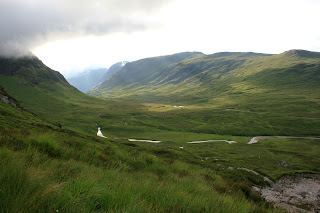 Somewhere out there was Ben Nevis, but it was hidden in the clouds. We took lots of photos, including the requisite self-portrait (above), before heading down. It took close to an hour to get back because the going was even more treacherous downhill. As we reached the end of the coire, we stopped briefly to watch the evening light streaming through the clouds down the green-gold glen (photo, right). It was one of the most awe-inspiring scenes of our entire trip.
We made it back to the car just before 7:00 p.m. We drove back to the hotel (John said he would only stop if I saw a UFO) and cleaned up for dinner in record time, as we knew they stopped serving food at 9:00 and we were really hungry! We sampled a couple more of the local ales – Crofter’s Pale Ale and Brewhouse Special. We sat at our “usual” table (#5); John had a wild boar burger and I had a chili beef burrito. For dessert we shared a hefty portion of apple and blackberry crumble (sadly they were all out of sticky toffee pudding). After dinner we still wanted to cool off from our hike so we went outside and sat at a picnic table to admire the view. A German couple we had seen in the pub came out and we saw them staring at our car. They went for a little stroll, during which time we went to our car to rearrange things for our departure tomorrow. The couple returned and approached us, addressing us in German, so we ended up having a nice chat with them, mostly in German. They had recognized that our car was from Böblingen and we spent a few minutes discussing Mercedes. It turns out the couple was on a tour, hiking portions of the West Highland Way, and we commented on the fact that we have seen quite a few Germans in Scotland but not in the rest of the U.K.
So what did we learn today? Life is about making choices. We could have chosen to climb Buachaille Etive Mòr earlier in the day, in which case we probably would have made it to the top and therefore been able to brag that we had “bagged a Munro.” Instead we enjoyed fabulous weather on the coast and experienced a relatively remote and gorgeous area of Scotland. For all we know, the top of Buachaille Etive Mòr was in the clouds most of the day. We did, however, get a good taste of real “hill-walking” and now we have a goal for our next trip to the Highlands!
 Our plan was to drive up the coast past Fort William to Glenfinnan, then on through Moidart and Sunart (traveling counterclockwise on the A861) and along the north shore of Loch Linnhe back to Fort William (with the option of taking the ferry across Loch Linnhe from Ardgour to Corran). When we reached
  We continued along a lovely stretch of two-lane highway to Glenfinnan, where we stopped at the visitor center and walked out to the Jacobite Rebellion monument: a statue of a Highlander atop a tall stone column, erected by Alexander MacDonald in 1815, which stands lonely watch at the head of Loch Shiel. This is perhaps one of the most well-known vistas in
  The German couple was still with us as we headed down the south side of Loch Ailort on the A861, but we eventually left them behind. Loch Ailort is actually a long, narrow finger of the Sound of Arisaig, so it is tidal, and the rocky hillocks rising out of the water were ringed with bright rust-colored seaweed. When we finally reached the sea, we were treated to a spectacular view out to the hazy blue islands of Rum, Eigg, and Muck, which seemed to float on the horizon between the cloud-flecked sky and steel-gray waters of the Sound. (The photo of John at right was taken at the mouth of Loch Ailort.)
  The single-track road followed the tranquil shoreline, dotted with cottages and farms and of course the ubiquitous sheep out grazing in the salt marshes. We passed the Corran ferry just as it was casting off from Ardgour; not knowing how long it would be until the next ferry, we decided to continue our circumnavigation of
  We got out our guidebook and reread the description of the climb up Buachaille Etive Mòr (or rather the 1022-meter Stob Dearg, as the name Buachaille Etive Mòr applies to the entire ridge). We hoped that we could at least make it to the ridge between Stob Dearg and Stob na Doire, at the top of a steep, rocky gorge called Coire na Tulaich (click on the photo at right to view our route; the red dot marks where we stopped). We quickly put on our boots and struck out at about 5:30 p.m. This might sound a bit loony, but keep in mind that it would stay light until about 11:00. We crossed the River Coe via the wooden footbridge, passed the little white Lagangarbh Cottage that sits squatly in the middle of the glen, and started up Coire na Tulaich, which cuts straight down the side of the mountain. We soon crossed the stream that comes cascading down the coire (the one that the guidebook says is usually dry in summer – ha!), and then the going started getting really rough. We were half walking, half scrambling over small boulders as we traced the faint outline of a trail up the right side of the coire. In some places there were distinct steps fashioned out of the rock, and we tried to imagine how much effort it must have taken to lug all those stones into place for our benefit!
  Part-way up the coire, John caught sight of a small bachelor herd of red deer grazing on the slope above us (I had been too focused on the rocks in front of me to notice them). They were gorgeous, with fuzzy coats and felt-covered antlers. The youngest of them (judging by his antlers), which was the closest to us, stopped and stared as we passed. He had a sort of wary, inquisitive look that indicated to me that he hadn’t seen too many humans in his life. We spotted two more deer grazing on the slope on the opposite side of the coire.
  We figured we were still about half an hour from the ridge and it would have been very rough going, picking our way straight up what was essentially a massive rockslide. I was incredibly disappointed, as I was really hoping that we could “bag a munro,” but I knew John was right. According to our Glencoe guidebook we were defying just about every rule of the mountains: we had no map or compass, no one knew where we were, we weren’t equipped for bad weather, we had no flashlight or first aid kit, we had started late, and our food and water supplies were minimal. Basically if anything happened to us up on the mountain or the weather turned for the worse, we were screwed, despite the fact that we were still within sight of our car. So we stopped where we were and sat on a rock, eating our candy bars and sharing an orange while taking in the gorgeous view across the glen. We could see the zigzag route of Devil’s Staircase distinctly, carved into the hillside across the valley (see photo of yesterday's hiking route, above), and beyond it the mountains faded away into the clouds in undulating waves of green and blue. We could even see the dam at the mouth of the Blackwater Reservoir.
  Somewhere out there was
No comments:
Post a Comment