Tuesday, September 25, 2007

4 July: Glencoe to Edinburgh Via Stirling

This morning I was somewhat depressed about saying farewell to the Highlands after such a brief taste of this magnificent region. And to think that I had at one point considered cutting Scotland out of our itinerary altogether, because I was worried that it would be too far to drive! I was, however, really looking forward to my first visit to Edinburgh, the city where I had once hoped to take a semester abroad (my parents decided – wisely, in retrospect - that I should go to Montpellier and study French instead). Before we leave Glen Coe behind I should point out that while we were not all that impressed with the Clachaig Inn (that mattress was truly awful!), if you want to hike in Glen Coe, it's hard to imagine a better-situated base of operations. There is another place called the Kings House Hotel a bit east of the Altnafeadh trailhead that might also be worth a look.

I failed to mention that we had our one and only left-hand driving “scare” while we were in the Highlands. John had pulled onto the right side of the road somewhere in Rannoch Moor to oblige one of my numerous requests for a photo-op. Of course the right side is, in effect the “wrong” side of the road to pull off onto in the U.K., but there was no place to stop on the left side. When John got back on the road, he automatically pulled into the right, or near, lane, which of course is what one would normally do when driving on the right side of the road. I looked ahead and saw a car coming straight at us in our lane, fortunately still several hundred yards away. I frantically gestured to the left, shouting, “Get over! Get over!” It took John a moment to realize exactly what I was making a fuss about, then he moved safely into the left lane. Fortunately this only happened once!

After checking out of the Clachaig, we retraced our steps through the Gorge of Glen Coe, stopping to take pictures of the cascading waterfall (photo, right), and back across Rannoch Moor, where I made a final attempt to capture the essence of that awesome, brooding landscape. We stopped at an overlook on the other side of the moor to watch a couple of red deer, up close and personal (they were being fed by a woman selling souvenirs out of her RV).

We headed southeast back towards the Trossachs and decided to make a pit stop in Callander, gateway to the Highlands and home of the Rob Roy and Trossachs Visitor Center, which documents the life of the highly romanticized Rob Roy MacGregor (despite Liam Neeson’s honorable portrayal, the man was apparently a common cattle thief and embezzler). Unfortunately you had to pay an entry fee to see the exhibit, so after taking a look around the gift shop and a quick stroll down Callender’s rather dreary main street, we decided to continue on our way.

Our next stop was Doune Castle, a very well-preserved medieval castle situated on the River Teith near Stirling, best known for its multiple appearances in Monty Python and the Holy Grail (photo, right). The castle was constructed near the end of the 1300s for Robert Stewart, the first Duke of Albany. He was the third son of King Robert II and younger brother of King Robert III, and became the ruler of Scotland himself (as regent for his ill brother) from 1388 until his death in 1420. Doune Castle later became a royal retreat and hunting lodge, then passed into the hands of the Earls of Moray towards the end of the 16th century. During the Jacobite uprising of 1745, the castle served as a prison for English supporters captured by the Jacobites. In 1984, the 20th Earl of Moray turned the castle over for public use and it is now maintained by Historic Scotland.

We approached the castle from the north, parking in the small gravel lot outside the main entrance. The sun was out for once, so we laid out a blanket and had a little picnic in the grass before touring the castle. The castle is laid out in a square, with a traditional L-shaped tower house. We entered the courtyard (photo, right) through a long, vaulted passage, paid the entrance fee, and proceeded on a self-guided tour of the castle’s fascinating labyrinth of chambers, stairways, and passages. The Lord’s Hall, Great Hall, and upper hall are all impressive; only the Lord’s Hall has been refurbished while the rest of the rooms are stark, stone-walled, and suitably gloomy. The kitchen features an enormous fireplace that takes up the full length of one wall. From the wallwalk we enjoyed terrific views down the River Teith and back towards the rolling green hills of the Trossachs.

Back in the courtyard, we were flagged down by a Historic Scotland volunteer who asked us if we would mind taking a ten-minute survey about our visit. We obliged, and had a nice chat with her as she filled out our responses on a handy little computer gadget. When we were done, she told us that we were so nice, she didn’t want to talk to anyone else! On our way out of Doune I asked John to stop at the bridge over the River Tieth so I could get the obligatory castle-on-the-river photo. A gray horse stuck his head over a stone wall nearby and watched me curiously. While John was turning the car around to pick me up, he scraped a curb, which put him in a foul mood for a while.

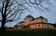
Our next stop was just a few miles down the road: the lively town of Stirling and its famous castle. Stirling was one of the most pleasant towns we passed through on our entire trip and I wouldn’t mind returning there to spend a little more time. It has been referred to as a “little Edinburgh,” with its castle perched high on a rocky volcanic outcropping (photo, right), surrounded by a bustling downtown shopping district and green parklands. Stirling Castle sits at a highly strategic position on the River Forth; it was the most important prize in the Scottish wars for independence and was used extensively by the Stewart monarchs – all factors supporting the argument made by some that Stirling, rather than Edinburgh, should be the capital of Scotland.

Our aim on this visit was first and foremost to see the castle, one of the largest and historically significant castles in Great Britain, so we followed the signs around the base of the outcropping, through the streets of the old city lined with stately townhouses and shops, and up a narrow road to a large parking area near the castle gates. From the outer ramparts we had magnificent views across the plain towards the Firth of Forth and back towards the Trossachs. An imposing statue of Robert the Bruce stands in front of the main gate; from the ramparts you can see Stirling Bridge, the site of William Wallace’s victory over the English in 1297, and Bannockburn, where Robert the Bruce defeated the English in 1314, securing Scottish independence for the next four centuries. Marjory, daughter of Robert the Bruce, married Walter Fitzallan, the high steward of Scotland, and their descendants produced the Stewart dynasty, including Mary, Queen of Scots, who was crowned as an infant in Stirling’s Chapel Royal in 1543.

We proceeded through the main gate in the 17th-century outer defenses into the Guardhouse Square, where we purchased a multi-day Historic Scotland pass, which would get us into Edinburgh Castle as well (we really should have bought this at Doune Castle, which would have saved us a little money). We also opted for the audio tour, which provided an entertaining and informative overview of the castle’s major features and historic highlights. We then passed through the mighty twin-towered Forework gate (photo, above) into the castle proper. Most of the castle’s main buildings date from the 15th and 16th centuries, including the splendid stone Palace block, which combines Renaissance and gothic details. From the ramparts we learned about the various sieges on the castle (there were at least sixteen), the mighty cannons used to defend it, and looked down on the remains of the formal palace gardens, whose outlines can still be seen in a series of tiered lawns (photo, right). We descended into the stone foundations to see the remains of the Prince’s Tower and learn about the earlier defensive constructions, then proceeded into the inner close to tour the Great Hall, the Chapel Royal, and the King’s Old Building.

The soaring Great Hall (photo, right), believed to date from the early 16th century and the reign of James IV, was recently restored to its original appearance after being used as a military barracks for years. It is the largest hall in Scotland (far larger than the hall at Edinburgh Castle), with an impressive hammerbeam ceiling. The exterior is limewashed an unusual pale yellow, which is presumed to be a close approximation to the color used in medieval times.

We took a quick peek into the beautifully restored Chapel Royal, which stands on the foundations of the original 12th-century chapel, but there was a concert going on so we didn’t linger long. The chapel seen today was completed in 1594, in time for the christening of Prince Henry, son of James VI of Scotland, who was later to inherit the unified crowns of Scotland and England. Lest you think that all my talk about sunshine and those bits of blue sky in my photos mean that we finally enjoyed a day without rain, let me point out that during our visit we had to take shelter from a sudden rain squall, which allowed me to take a nice photograph of the inner close (below) with hardly any people in it.

Finally, we toured the King’s Old Building, which sits at the highest point on the castle’s rocky promontory (on the left in the photo, with the Chapel Royal on the right). It was built for James IV around 1496, but probably rests on the foundations of several older structures. Originally containing the royal apartments, it housed officers for the military garrison stationed here from the late 17th century onwards. Today it houses the regimental museum of the Argyll and Sutherland Highlanders, which we toured quickly. The entire structure has been altered repeatedly over time, so its restoration has posed a challenge. Most of the rooms are in an unfinished or “stripped” state, as archaeological work continues, but you can see some interesting artifacts, including an ancient stone hearth bearing original carvings of the royal thistle (the official symbol of Scotland) and a beautifully restored casement window. The structure surrounds a central courtyard known as the “Lion’s Den,” where a Scottish monarch purportedly kept a lion at one point.

Next we toured the kitchens, where an exceptional life-size diorama illustrates the hectic flurry of servants preparing a medieval feast for their royal masters. Finally, we passed through the North Gate, perhaps the castle's oldest standing structure (dating to 1380), and proceeded to the buildings of the Nether Bailey and the North Curtain Wall. From here we had a good view looking back up at the Great Hall and out across the plain to the Trossachs. Several blast-proof powder magazines were built here in the 19th century, and you can tour a small guardhouse that was converted into a punishment cell for wayward soldiers. Nearby, a new building houses the tapestry studio, where a team of artists is carefully recreating tapestries to hang in the restored Palace (unfortunately we arrived after the studio had closed for the evening).

It was now past 5:00 and we had to press on to Edinburgh, arriving right at rush hour, of course, so it took us a bit longer than planned to make it to the Elmview, our home for the next two nights. The Elmview is a luxurious B&B located within walking distance of Edinburgh’s Old Town, in a lovely rowhouse alongside a broad expanse of green lawn called The Meadows (popular for golf practice). We were greeted warmly by our hosts, Robin and Nici Hill, who hail from Salisbury and took over the Elmview from Robin’s brother in 2004. Robin showed us around our spacious room (photo, right), with a king-sized bed, floor-to-ceiling windows looking out to a lovely private garden, thoughtful furnishings (including a crystal carafe of cream sherry on the writing desk), and a lovely tile bathroom with all the comforts of home.

Before we went to dinner, we needed to park our car in the Elmview's private car park. As in most any thriving European city, parking is in extremely high demand in Edinburgh, and one of the reasons I had chosen the Elmview was that it offered free, private parking. Well...this is all true, but the parking consists of three tiny spaces in a small enclosure a few blocks from the house. Robin handed us a key and a much-abused sheet of paper with instructions on how to get to the car park. Because of the one-way streets in the neighborhood, you have to make a huge loop in order to drive to the location, even though it is only a few hundred feet away. We safely navigated our way to the gate, which I unlocked, and swung the doors open as wide as they would go. Fortunately we were the first guests to arrive with a car tonight, so John had only to back the E-Class carefully into the far left corner, reorienting the car about twenty times in the process. How we were going to get the car out again - particularly if anyone else was parked next to us - was anyone's guess. But the car was staying put for the next two nights, so we would just have to cross that bridge when we came to it.

Robin recommended dinner at The Apartment, right down the street. We took his advice and by calling ahead were able to secure a reservation at 8:30, as long as we were willing to share a table, because they have picnic-table style seating. We found The Apartment to be an eclectic, modern place with a slight attitude (probably stemming from its obvious popularity among the trendy crowd) and somewhat unpredictable service, but we enjoyed our meal. We were seated at a long table shared with one other couple, so it wasn’t tight at all, but I could have done without the wooden cubes that passed for seating – a chair with a back would have been nice after a long day in the car. We had to wait a long time for our bottle of wine and then were not asked if we wanted to taste it. The innovative menu is divided into four categories: CHL (Chunky Healthy Lines, which are skewers featuring various combinations of meat, vegetables, and interesting marinades), Fish Things, Other Things, and Salad. John had a salmon dish and I had an Asian-inspired sea bass papillote cooked with lemon grass. We both had the chocolate pecan brownie with raspberry shortcake ice cream for dessert, which was excellent!

Before we turned in for the night, I took a picture of the view across the Meadows at 10:30 pm (right), demonstrating how light it is on a midsummer's night in Scotland!

Sunday, September 23, 2007

3 July: A Coastal Drive & Our Attempt to "Bag a Munro"

We were up at 7:30 a.m. and repeated our breakfast routine from yesterday. As we were getting ready to leave the inn, we looked outside and it was, of course, raining! Based on the posted forecast (which the front desk staff update regularly), we decided to head for the coast and take a scenic drive rather than attempting another hike, although we did hold onto a vague scrap of hope that the clouds would thin out in the afternoon and we just might be able to squeeze in a hike.

We headed first to the Spar grocery store (a German chain, ironically) in Glencoe village to buy a few lunch items. Then we stopped at the Glencoe Visitor Center, which is a brand-new eco-friendly building, but didn’t see the exhibit since it cost £5 each and we didn’t want to linger too long. We did visit the very nice gift shop, which has an amazing collection of Scottish history books and novels. We bought an inexpensive guidebook to the Glencoe area that has some gorgeous pictures (you know, all the gorgeous pictures that I wanted to take but couldn’t because of the weather). There is a section in the book with quotes from local schoolchildren about “what the Glen means to me” and one 11-year-old boy wrote, “My only dislike in Glencoe is that it is usually raining, which is a bit annoying when you have everything you want on your doorstep.” Only later would we learn that Glen Coe is one of the wettest areas of Scotland!

Our plan was to drive up the coast past Fort William to Glenfinnan, then on through Moidart and Sunart (traveling counterclockwise on the A861) and along the north shore of Loch Linnhe back to Fort William (with the option of taking the ferry across Loch Linnhe from Ardgour to Corran). When we reached Loch Linnhe, a generous swath of blue sky was visible through the clouds – our first hint that the day was not going to be altogether ruined. On the way to Glenfinnan we passed Neptune’s Staircase, a series of eight locks that allow ships traveling the Caledonian Canal to climb or drop 64 feet in the space of less than half a mile. We stopped at the last lock and walked a short way along the towpath. From here we got a brief glimpse of the imposing, rounded peak of Ben Nevis rising through the clouds, just southeast of Fort William (the highest mountain in the photo, above).

We continued along a lovely stretch of two-lane highway to Glenfinnan, where we stopped at the visitor center and walked out to the Jacobite Rebellion monument: a statue of a Highlander atop a tall stone column, erected by Alexander MacDonald in 1815, which stands lonely watch at the head of Loch Shiel. This is perhaps one of the most well-known vistas in Scotland, thanks to its use as a backdrop in numerous movies, including the Harry Potter films. The monument marks the spot where Bonnie Prince Charlie officially began the Jacobite uprising of 1745, which ended tragically with the Battle of Culloden on the other side of Scotland the following year. It was a rather moody scene, with low clouds and a light rain falling – fittingly Scottish! We bought some Highland fudge and toffee at the gift shop and then hiked up to the viewpoint above the visitor center, where we got a good view of the monument and Loch Schiel on one side (photo, above) and, in the opposite direction, the 21-arch concrete viaduct across Loch nan Uamh, built in 1901 and famously traversed by the Hogwart’s Express in the Harry Potter movies.

From Glenfinnan we continued west on the A830 to Lochailort, through a gorgeous landscape of sweeping mountains, deep green glens, and rippling lochs. We found ourselves leapfrogging a young German couple as we both kept stopping for pictures at every good turnout. At one point I got out of our car to take a picture of Loch Eilt. The German couple was already there and the woman walked up and asked me, in German of course, if I could take their picture. I said, “Natürlich!” and then “Bitte schön!” hoping that she wouldn’t realize that I wasn’t German!

The German couple was still with us as we headed down the south side of Loch Ailort on the A861, but we eventually left them behind. Loch Ailort is actually a long, narrow finger of the Sound of Arisaig, so it is tidal, and the rocky hillocks rising out of the water were ringed with bright rust-colored seaweed. When we finally reached the sea, we were treated to a spectacular view out to the hazy blue islands of Rum, Eigg, and Muck, which seemed to float on the horizon between the cloud-flecked sky and steel-gray waters of the Sound. (The photo of John at right was taken at the mouth of Loch Ailort.)

We followed the rugged coastline for a few miles. Somewhere along this stretch is a rock cairn marking the spot from which Bonnie Prince Charlie set sail on his final escape to France, never to return to his homeland. We headed inland along Loch Moidart to Kinlochmoidart and over a low pass to the tiny town of Acharacle, stopping along the way for lovely views of the tail end of Loch Shiel. The road was single-track for most of the stretch from Kinlochmoidart to Strontian, but there were plenty of signed “passing places.” We stopped at a roadside tourist office (in Salen, I think) to use the restrooms and then headed east along Loch Sunart to Strontian. (Alternatively, you can turn west at Salen and take the very narrow B8007 all the way to Ardnamurchan Point, the westernmost point on the British mainland.) Little-known fact: the town of Strontian gave its name to the element strontium, which was discovered there in 1722.

We felt very “out there,” although the landscape was dotted with plenty of B&Bs, self-catering cottages, and even an RV park to support what is obviously a significant tourist industry. Eventually we reached Inversanda and began the long, slow crawl along the northern shore of Loch Linnhe. The single-track road followed the tranquil shoreline, dotted with cottages and farms and of course the ubiquitous sheep out grazing in the salt marshes. We passed the Corran ferry just as it was casting off from Ardgour; not knowing how long it would be until the next ferry, we decided to continue our circumnavigation of Loch Linnhe and Loch Eil by road. It was another 35 very slow miles back to Fort William from Ardgour, but the views were magnificent! At one point we could see across Loch Linnhe straight up the mouth of Glen Coe, the Pap of Glen Coe at the western end of Aonach Eagach just visible beneath a bank of clouds (photo, right).

On our way back to Fort William, Ben Nevis was once more hidden in the clouds. We stopped for gas in Fort William and then headed straight back to Glen Coe, where the clouds seemed to be breaking up again. I was still holding out hope that we might take a short hike, depending on the weather in the glen, so we passed the turnoff for the inn and continued east, through the gorge, and back to the Altnafeadh pull-off where we had parked yesterday for our hike up Devil’s Staircase. We got out our guidebook and reread the description of the climb up Buachaille Etive Mòr (or rather the 1022-meter Stob Dearg, as the name Buachaille Etive Mòr applies to the entire ridge). We hoped that we could at least make it to the ridge between Stob Dearg and Stob na Doire, at the top of a steep, rocky gorge called Coire na Tulaich (click on the photo at right to view our route; the red dot marks where we stopped). We quickly put on our boots and struck out at about 5:30 p.m. This might sound a bit loony, but keep in mind that it would stay light until about 11:00. We crossed the River Coe via the wooden footbridge, passed the little white Lagangarbh Cottage that sits squatly in the middle of the glen, and started up Coire na Tulaich, which cuts straight down the side of the mountain. We soon crossed the stream that comes cascading down the coire (the one that the guidebook says is usually dry in summer – ha!), and then the going started getting really rough. We were half walking, half scrambling over small boulders as we traced the faint outline of a trail up the right side of the coire. In some places there were distinct steps fashioned out of the rock, and we tried to imagine how much effort it must have taken to lug all those stones into place for our benefit!

Part-way up the coire, John caught sight of a small bachelor herd of red deer grazing on the slope above us (I had been too focused on the rocks in front of me to notice them). They were gorgeous, with fuzzy coats and felt-covered antlers. The youngest of them (judging by his antlers), which was the closest to us, stopped and stared as we passed. He had a sort of wary, inquisitive look that indicated to me that he hadn’t seen too many humans in his life. We spotted two more deer grazing on the slope on the opposite side of the coire.

We made very good time and were perhaps half-way up the mountain after about 40 minutes, but we had set our turn-around time at one hour. As 6:30 approached, the last stretch of scree was still looming above us, topped by a near-vertical rock face. We thought we could make out a set of steps cut into the rock. I was really hoping we could make it all the way to the ridge, because the sun was coming out and I knew the views from up there must be incredible. I convinced John to continue for ten more minutes. Just as we reached a point where the trail seemed to peter out altogether, my ever-rational husband said we had to call it quits. We figured we were still about half an hour from the ridge and it would have been very rough going, picking our way straight up what was essentially a massive rockslide. I was incredibly disappointed, as I was really hoping that we could “bag a munro,” but I knew John was right. According to our Glencoe guidebook we were defying just about every rule of the mountains: we had no map or compass, no one knew where we were, we weren’t equipped for bad weather, we had no flashlight or first aid kit, we had started late, and our food and water supplies were minimal. Basically if anything happened to us up on the mountain or the weather turned for the worse, we were screwed, despite the fact that we were still within sight of our car. So we stopped where we were and sat on a rock, eating our candy bars and sharing an orange while taking in the gorgeous view across the glen. We could see the zigzag route of Devil’s Staircase distinctly, carved into the hillside across the valley (see photo of yesterday's hiking route, above), and beyond it the mountains faded away into the clouds in undulating waves of green and blue. We could even see the dam at the mouth of the Blackwater Reservoir. Somewhere out there was Ben Nevis, but it was hidden in the clouds. We took lots of photos, including the requisite self-portrait (above), before heading down. It took close to an hour to get back because the going was even more treacherous downhill. As we reached the end of the coire, we stopped briefly to watch the evening light streaming through the clouds down the green-gold glen (photo, right). It was one of the most awe-inspiring scenes of our entire trip.

We made it back to the car just before 7:00 p.m. We drove back to the hotel (John said he would only stop if I saw a UFO) and cleaned up for dinner in record time, as we knew they stopped serving food at 9:00 and we were really hungry! We sampled a couple more of the local ales – Crofter’s Pale Ale and Brewhouse Special. We sat at our “usual” table (#5); John had a wild boar burger and I had a chili beef burrito. For dessert we shared a hefty portion of apple and blackberry crumble (sadly they were all out of sticky toffee pudding). After dinner we still wanted to cool off from our hike so we went outside and sat at a picnic table to admire the view. A German couple we had seen in the pub came out and we saw them staring at our car. They went for a little stroll, during which time we went to our car to rearrange things for our departure tomorrow. The couple returned and approached us, addressing us in German, so we ended up having a nice chat with them, mostly in German. They had recognized that our car was from Böblingen and we spent a few minutes discussing Mercedes. It turns out the couple was on a tour, hiking portions of the West Highland Way, and we commented on the fact that we have seen quite a few Germans in Scotland but not in the rest of the U.K.

So what did we learn today? Life is about making choices. We could have chosen to climb Buachaille Etive Mòr earlier in the day, in which case we probably would have made it to the top and therefore been able to brag that we had “bagged a Munro.” Instead we enjoyed fabulous weather on the coast and experienced a relatively remote and gorgeous area of Scotland. For all we know, the top of Buachaille Etive Mòr was in the clouds most of the day. We did, however, get a good taste of real “hill-walking” and now we have a goal for our next trip to the Highlands!

Friday, September 21, 2007

2 July: The MacDonald Massacre & Devil's Staircase

We woke up and looked out the window this morning and couldn’t see anything. Aonach Eagach was completely obscured by low-hanging clouds, from which a steady rain was falling. Needless to say, we didn’t rush to get going. For breakfast we had a choice of big, bigger, or vegetarian. We chose the “Boar Breakfast” (“big”), which was the full English breakfast with a Scottish twist: wild boar bacon and sausage, baked beans, and a “tattie cake” (thin potato pancake), in addition to the usual fried egg, broiled tomato, mushrooms, and toast. Of course we could have opted for “The Whole Hog,” which included all of the above, plus haggis and black pudding. The menu proudly proclaimed that this meal would “not just set you up for the day, but probably the whole night as well!” It might be sacrilegious to say this, but I really have no strong desire to sample haggis, a classic Scottish dish consisting of some combination of sheep entrails (heart, liver, lungs, etc.) minced with onion, oatmeal, suet, and spices and traditionally boiled in a casing made of sheep’s stomach. According to various accounts, haggis developed as a means to make use of the parts of the animal that would otherwise go to waste, were comparatively inexpensive and easy to come by, or were likely to go bad quickly. While I strongly support the idea of putting all of an animal’s parts to good use once it’s dead, I think I will leave haggis to the die-hard carnivores out there, even if it means missing out on a critical aspect of Scottish culture. Black pudding is blood sausage, and since I’ve already tried German blutwurst, I wasn’t all that eager to sample the Scottish version. I contented myself with a bowl of Highland porridge to accompany my Boar Breakfast, although I saw no sign of the “heather honey” and “whisky cream” that were advertised on the menu. The coffee was great, however!

We drove into Glencoe first, as we wanted to visit the MacDonald monument on the edge of town, which memorializes a dark chapter in the history of the glen. Back in the 17th century, the Highland clans were strongly divided in their political allegiance. Clan Campbell backed the Protestant King William of Orange (William III), while the MacDonalds were Jacobites, supporters of the Catholic James VII (“Bonnie Prince Charlie”), whom they believed to be the rightful King of England. By the late 1680s, the possibility of a Jacobite rebellion had become very real, and in August 1691 the English government announced an Indemnity, which stated that all Jacobite clan chiefs who swore allegiance to King William would be freed of any penalties for previous crimes and would be protected under the Crown. A deadline of January 1st, 1692 was set for the chiefs to take the oath; any clans who refused would be treated severely under the law as traitors and rebels.

The Jacobite chiefs, including MacIain of the MacDonald clan of Glencoe, would not take the oath without James’ approval, but James was exiled in France and his message did not arrive in Glencoe until perhaps as late as the 29th of December, two days before the deadline. MacIain set out in heavy snows for Fort William to give his oath to Colonel Hill there, not realizing that he was actually supposed to take the oath at Inveraray. Upon arriving at Fort William, MacIain learned of his error, and had to lead his men another sixty miles, again in the snow, to Inveraray. They were detained by government troops and did not arrive in Inveraray until January 3rd, where MacIain was eventually allowed to take the oath of allegiance. Unfortunately, the Privy Council in Edinburgh refused to acknowledge his oath and effectively had the clan blacklisted.

Orders to “act against these Highland Rebells…by fire and sword…and by all manner of hostility to burne their houses, seise or destroy their goods or Cattell…and to cut off the men,” were transmitted down the line from John Dalrymple, Master of Stair, to Sir Thomas Livingstone, commander of the King’s armies in Scotland, to Colonel Hill at Fort William (who was sympathetic to the Highlanders and thus distanced himself from the events), and finally to Hill’s deputy, Lieutenant Colonel Hamilton, who seemed almost giddy at the prospect of destroying the MacDonald clan. In the end, 120 redcoat soldiers led by Captain Robert Campbell arrived in Glencoe on February 1st with a letter from Colonel Hill instructing the MacDonalds to board the soldiers in their homes. Highland tradition called for the clans to offer each other such hospitality, even those on opposite ends of the political spectrum, but in reality the MacDonalds had little choice but to obey the orders.

For twelve days, Campbell’s troops slept and ate with the villagers of Glencoe. On the 12th of February, Captain Campbell received his final instructions to attack Glencoe at 5 o’clock the next morning. He was specifically ordered to execute MacIain and his sons and to kill every man under the age of 70. MacIain was the first to fall, killed by a bullet to the back inflicted by Campbell’s deputy. In all, at least 38 boys and men were killed and more died of exposure after attempting to escape into the hills. Many members of the clan survived, including MacIain’s two sons, perhaps due in combination to the bad weather, the MacDonalds being alerted by the first shots, and the unwillingness of the soldiers themselves to betray their hosts. It was this atrocious breach of Highland hospitality that made the massacre famous, and to this day some degree of animosity remains (we saw at least one sign indicating that Campbells were unwelcome).

The MacDonald oath was eventually acknowledged by the Privy Council and the clan members rebuilt their homes in Glencoe under the leadership of MacIain’s son John. The clan continued to support James and fought for the Jacobite cause in the Battle of Culloden in 1746. Members of the MacDonald clan owned property in Glencoe until the mid-20th century, when the lands were consolidated under the National Trust for Scotland. Today a stone cross stands on the outskirts of Glencoe, erected in 1883 by Ellen Burns MacDonald, MacIain’s direct descendant, to honor the clansmen who fell on that cold wintry day in 1692. We visited the monument, which stands on a small rocky outcropping surrounded by the glen’s craggy peaks (photo, above), and admired the view from a beautiful single-arched stone bridge over the rushing waters of the River Coe.

A few patches of blue sky were peeking through the clouds by now, so we decided to take a chance on the weather and go for a hike up the Devil’s Staircase, a small segment of the famous West Highland Way. We retraced our route up the Glen a few miles to the roadside pulloff at Altnafeadh, near the base of Buachaille Etive Mòr. A couple of other cars were parked there, but we still felt a little odd leaving our car totally exposed at the side of the road. It was overcast but not raining as we started up the steep slope, outfitted with the best we could manage in terms of rain gear (raincoats, zip-off nylon pants, and our hiking boots, which we knew from our Goodwood experience were slightly less than waterproof). The trail zigzagged up a moderately steep slope alongside a gurgling stream ("Devil’s Staircase" makes it sound worse than it is; the name was given by soldiers who constructed the trail under much more adverse conditions in the 17th century). The sound of water was everpresent, even though the stream sometimes disappeared beneath the peaty soil. The heather was in bloom all around us, its tiny fuschia blooms brightening the scene, along with a variety of wildflowers including yellow and purple saxifrage and the miniscule lavender-hued heath spotted orchid. We hadn’t gotten very far when it started to sprinkle, but only lightly, so we decided to keep going. After about forty minutes we reached the pass, the highest point on the West Highland Way (about 1600 feet, according to the Clachaig Inn’s hiking guide), which was marked by a large rock cairn. From here we had a relatively clear panorama up and down the glen, including a gorgeous view across the valley to Buachaille Etive Mòr (photo, above) and its little brother, Buachaille Etive Beag (Little Herdsman of Etive), to the west.

At this point we had several options. The trail continued on down the other side of the pass to the town of Kinlochleven, but there was no way for us to get back to our car without retracing the entire route or taking a bus, and we had no information about the bus schedule. We could hike east out to a low rise to try to get a better view of Rannoch Moor, or we could hike west up a steep, rocky slope to a small outcropping above us, which had been periodically enveloped in clouds as we were hiking up to the pass. The outcropping was hidden in a cloud right now, so we opted for the lower route and the moor view. We followed a sporadic footpath over uneven, water-logged terrain to a cairn overlooking what turned out to be a large reservoir (we later identified it as the Blackwater Reservoir). Rannoch Moor was actually mostly hidden around another mountain to the east. We stopped here for lunch, which consisted of salami, crackers, a tomato (the last of our Sussex Pad provisions), and a granola bar. It started blowing rain around this time so we quickly packed up, took a few pictures (photo, above), and headed back to the main trail. Along the way we stopped to investigate some of the marshy pools that dotted the landscape. The edges of the pools were thickly carpeted with clumps of red and yellow bog moss (photo, right) and feathery liverwort, and a narrow-bladed grass variegating from green to bright red was growing right out of the water.

The rain had let up and the mountain above us was mostly clear when we arrived back at the cairn, so we decided to head upwards. It was slow going, as the trail was not much more than a muddy sheep track. Our efforts were rewarded when we reached the top of the knob of rock we had seen from the cairn – the clouds cleared for about thirty seconds and we got an incredible panorama of the glen, from the edge of Rannoch Moor all the way to the Three Sisters, with the thin silver ribbon of the A82 bisecting the valley below us. I scarcely had time to take my pictures before another cloud moved in and it started to rain again. At this point our pants were beginning to soak through and we knew it was time to call it quits. Fortunately the rain and wind lessened as we retreated down the mountain, so we didn’t get any colder or wetter, but we both agreed that it was a good time to turn back. After returning to our car we crossed the road and walked out to a wooden footbridge over the River Coe. We used our binoculars to try to find the trail up Buachaille Etive Mòr in front of us, as we are still entertaining the idea of trying to climb a “munro” tomorrow (what the Scots consider a “real mountain”, or anything above 3,000 feet). We’re not sure if the outcropping we climbed today has an official name, but it is at the easternmost end of the 9-kilometer ridge comprising the Aonach Eagach (I am pointing to the knob of rock that we climbed in the photo, right).

On the way back down the glen we stopped to get some pictures of the Three Sisters, whose peaks were momentarily clear of clouds, and then a bit further down the highway we finally got an up-close look at some Highland cattle. There are only about twenty or so left in the whole glen, so we were lucky that a few of them were grazing right near the road. They are incredibly cute, with shaggy red coats and long bangs falling over their eyes, giving them a rather bemused look (photo, right). We headed back to the hotel around 4:00 and got cleaned up for dinner. It was still early in the evening so we decided to make an outing to Fort William and find a place to eat there. We drove west out of the glen, along the south shore of Loch Leven, and finally saw the Scottish coast, rounded the point and heading up Loch Linnhe to Fort William. This was a very nice stretch of well-maintained tarmac, which the locals like to drive extremely fast. The road to Fort William was peppered with bed & breakfasts – it seemed like every house for several miles had a B&B sign out front. I can’t imagine how they all get enough customers to stay in business!

We looked for a seafood restaurant on the waterfront that was recommended in Fodor’s but couldn’t find it, so we parked in a visitor lot and walked down the High Street in search of dinner. We knew from our guidebooks that Fort William is not known for its charm; a dual carriageway (that's British for four-lane highway) effectively destroys the waterfront and the downtown area is a bit rough around the edges. There were a few people wandering around, but I couldn’t figure out how all those B&B guests could be supported by the apparently limited number of restaurants. Most of the places had the same basic fare – steaks and burgers, fish and chips, etc. We stopped to buy a couple of magnets in a curio shop and two very expensive bottles of single malt at The Whisky Shop (Glenfiddich Solara Reserve and Glenmorangie Port Wood Finish). We ended up eating at the Ben Nevis Restaurant, with a view out over Loch Linnhe (we have yet to see Ben Nevis itself – the highest mountain in the U.K.). I had fish and chips with peas (I had to have it at least once on this trip and it was very good here) and a Scottish bitter (pale ale) called McEwan’s. John’s roast beef plate was disappointing, with an overcooked, thin slice of meat, watery gravy, peas and carrots, and plain boiled potatoes. Plus he was driving so the poor man didn’t even get a beer! We decided to skip dessert and head back to Glen Coe, thinking we could have some of that awesome-looking sticky toffee pudding at the pub. But while we were at dinner the skies had cleared enough to expose a dramatic evening sky, so I made John stop about ten times on the way back (Loch Linnhe at dusk, right). It was the best light for photography that we’ve had on the whole trip! Unfortunately we got back to the inn after they stopped serving food in the pub (9 p.m., which seems rather unreasonable, especially when it is light out until almost 11:00), so we had to settle on a couple of single malts instead, chosen from the Clachaig’s stock of several hundred varieties. John had the Balvenie Portwood and I had Blair Athol, a local Highland whisky.

Tuesday, September 18, 2007

1 July: Grasmere to Glen Coe

We went downstairs to the Banerigg's cheery breakfast room around 8 a.m. and were served a generous full English breakfast by Angela. The only glimpse we got of her husband was through the little pass-through in the wall to the kitchen. We shared our table with a young woman from San Francisco who was eating alone because her husband wasn’t feeling well. She was a very typical San Francisco hippie hiker type. Actually it was pretty funny – John poured himself a glass of orange juice and set it down by his place, then went to get some fruit. In the interim, the San Francisco woman wandered in, sat down at John’s place, and started drinking his orange juice! You should have seen the look on John’s face when he returned to the table. He didn’t say anything, just stared for a moment, set his bowl of fruit down at the place next to me, turned around, and went to pour himself another glass of juice!

We checked out after breakfast and Angela waved us out of the driveway to make sure we didn’t meet an untimely end with one of the speeding cars coming ‘round the bend. We stopped briefly in Grasmere but most of the shops were closed – including a very nice-looking art gallery – because it was Sunday. It seems our brief impression of the Lake District will be one of incessant rain and mist-shrouded green hills, but it does look like a beautiful area. We headed north through the countryside, stopping occasionally to take pictures of lush sheep pastures and crumbling rock walls, which made for quite picturesque compositions despite the dreary weather (photo, right).

At the large town of Keswick, which marks the northern edge of the Lake District, we planned to head east towards Penrith and the M6, but we decided to detour slightly to visit Castlerigg, a circle of standing stones just outside of Keswick. The well-marked route led us out a country lane, where we parked along the road and walked a few hundred feet through a sheep pasture to reach the circle.

Castlerigg is one of the earliest stone circles in Britain, dating to around 3200 B.C., and is the most visited stone circle in Cumbria. The stones, made of local slate, are much smaller than those at Stonehenge (the tallest stone in this ring is 2.3 meters, compared with 7.5 meters at Stonehenge), but the circle’s lonely position atop a low rise, surrounded by windswept peaks and green fells, makes for quite a dramatic setting (photo, right). A few other people were exploring the site with us, including a family with young kids who insisted on playing tag between the stones (this is precisely why I was glad that Stonehenge is roped off!). Castlerigg consists of 38 stones laid out in a slightly flattened circle; only four are missing from the original configuration. A low rectangle of ten more stones stands within the ring, touching the edge of the circle on its eastern side. Astronomers have noted that the sun rises over the top of nearby Threlkeld Knott during the autumn equinox, and some of the stones are aligned with the midwinter solstice and various lunar positions. The circle was thought to be connected with the nearby Langdale axe-making industry, and two Neolithic polished axes were found at the site in the nineteenth century.

We wandered around the site for a while, contemplating its serene setting and enjoying the view of the surrounding countryside, then headed back to the car. We cut east to the M6 and then hightailed it north, past Carlisle, into Scotland. I tried to take a picture of the “Scotland Welcomes You” sign, but I was using our little point-and-shoot Canon and it focused on the raindrops on the windshield instead of the sign – effectively summing up our weather experience thus far! We passed Lockerbie (notable in our minds as the site of the 1988 Pan Am terrorist bombing) and hit heavy traffic as we approached Glasgow, which appeared to be caused by an accident on the M6. We did not hear until later that evening that there had been a terrorist attack at the Glasgow airport the night before, although when we passed the airport we noticed nothing amiss.

Susie, in all of her infinite wisdom, shunted us off of the motorway early and onto the A82, straight through downtown Glasgow. It was slow going but at least we got to see some of the city rather than being stuck in traffic on the motorway. We passed through an interesting area full of trendy interior design shops and then an ethnic quarter lined with Chinese and Indian restaurants. Once out of Glasgow we headed towards the town of Dumbarton and the Erskine Bridge. Unfortunately I was a little confused about where we were on the map and didn’t realize that we were already on the north side of the Firth of Clyde. I ignored Susie and told John to take the Erskine Bridge. It took us a few minutes to realize that we were headed south over the bridge, back towards the airport, instead of north! We started paying attention to Susie again and eventually got ourselves turned around and going in the right direction (fortunately there are no longer any tolls on the bridge!).

After this little blunder we had smooth (albeit slow) sailing up the A82, along the shores of Loch Lomond (the largest loch in Scotland, with a surface area of more than 27 square miles) and through the Trossachs, a scenic area of wooded glens and small lakes. The road was a winding two-lane highway that took us through dense forest along the lakeshore, past the famous Loch Lomond Golf Course, home of the Scottish Open. The scenery started becoming really dramatic as we turned northwest at Crianlarich and approached Rannoch Moor, a bleak fifty-square-mile expanse of boggy moorland, bristling with hardy rushes and pockmarked by gleaming pools and low hillocks (photo, right). I kept making John pull over so I could take pictures. Of course the pull-offs were never where I wanted my photos! The thin ribbon of the A82 cut straight across the moor, and we felt very small in the vast sweep of water, earth, and sky.

Finally we entered Glen Coe itself, said to be one of the most impressive glens in all of Scotland. (I had done my research carefully: my goal on this trip was to experience the Highlands without driving all the way to the farthest northern reaches of Scotland, and no other place fits the bill quite like Glen Coe, one of the most popular destinations for hikers and climbers in the whole of the U.K.) The awesome grandeur of the scenery is difficult to describe – impossibly green, glacier-carved slopes sweeping away in perfect arcs on either side of the road, topped by craggy peaks peeking in and out of swirling clouds. Everywhere the mountainsides were streaked with trickling streams and cascading waterfalls – never have I seen so much water! We passed the almost perfectly pyramidal form of Buachaille Etive Mòr, one of the most recognizable mountains in Scotland, although our first view of it was shrouded in mist. We proceeded through a narrow, rocky gorge to Bidean nam Bian, the highest mountain complex in Argyllshire, and stopped at the Three Sisters overlook to take in the panoramic peaks of Gearr Aonach (Short Ridge), Aonach Dubh (Black Ridge), and Beinn Fhada. Somewhere up between Beinn Fhada and Gearr Aonach lies Coire Gabhail, which means “Glen of Capture” but is more commonly known as the Hidden Valley or Lost Valley. Legend has it that the members of Clan MacDonald used to hide their stolen cattle here, as once you pass the glacial slide blocking its mouth, the glen itself is wide and flat – perfect for cattle grazing.

Just past the Three Sisters we found the well-marked turn-off for the Clachaig Inn, which is located a few kilometers down the old single-track road leading to the village of Glencoe. The Clachaig pretty much fit the description I found online – a hiker’s lodge with basic accommodations and casual pub dining – but nothing could prepare us for its awesome setting, smack in the heart of Glen Coe, with rugged mountains thrusting skywards on all sides. The inn consists of the original lodge building, which has served Highland travelers for some four hundred years, two modern wings, and two award-winning pubs, the Boots Bar and the Bidean Lounge (photo, right). We were greeted by a friendly hostess who showed us upstairs to our room in the newer Bidean wing (I had wanted a room in the older Ossian wing but they were booked), telling us quite matter-of-factly that we didn’t have “the greatest view.” Actually, our window looked out onto the roof of the neighboring wing, but if we craned our necks we could see part of Aonach Eagach, the long ridge of mountains to the north. Our room was miniscule, with a double bed, a tiny desk, an open closet, and not much else. The bathroom was equally tiny, but equipped, as we were soon to discover, with a very good shower (with better water pressure than we’ve had on the whole trip!). The only real negative was the mattress, which was one of the worst we’ve ever encountered in our travels – rather surprising for an inn that caters to outdoor enthusiasts who are primarily looking for a good night’s sleep!

We decided to go for a walk before dinner, as it was only about 5:30 p.m. We thought it was only a mile or so to the village of Glencoe, so we headed down the single-track road, just as it started to drizzle. Unfortunately “a mile or so” was an understatement and in the interim it started to rain quite heavily. We had our raincoats but no umbrellas with us. Finally we asked some folks who were walking in the other direction how far it was to town, and they said they had actually measured it at three miles. Suffice it to say that we decided to turn back, a few minutes after passing the Glencoe Youth Hostel and Bunkhouse. Before we turned back, we encountered a young man hiking alone in the opposite direction. He stopped to ask us for directions and we started to say that we had just arrived and didn’t know where anything was, but it turned out that he was looking for the youth hostel and we were able to tell him that it was just beyond the next bend. By the time we got back to the inn we were soaked through and had to go back to our room to change into dry clothes.

We went down to the Bidean Lounge for dinner, which is the “nicer” of the two pubs (by definition, you can come into the Boots Bar straight from the hiking trail but are supposed to remove muddy boots before entering the Bidean Lounge). It was very comfortable and casual, with lots of cushy leather couches in addition to regular dining tables. The place was busy, but we found room at a small round table in the corner near the entrance. A huge troop of college-age kids tromped in and pretty much took over the rest of the place. John had an Angus cheeseburger and I had a bowl of chili, both of which met our requirements of warm and filling. I ordered a couple of Scottish ales for us to sample – John had the Kelpie organic seaweed beer (don’t ask – it’s what the guy at the bar gave me!) and I had the William’s Gold, which was quite tasty. We were tempted by the sticky toffee pudding (the gentleman next to us, who had a very sweet Hungarian Vischla under his table, dug into his serving with gusto) but we decided we were full and called it a night. Before we headed upstairs, we checked out the weather forecast for the next two days: Rain.

Monday, September 17, 2007

30 June: From Wales to the Lakes

This morning we had the porridge oats again (they really do hit the spot on a blustery rainy day) and John had the full breakfast, but I just had a side order of bacon because I think eating all these eggs might kill me (yeah, I know, like eating bacon won't)! We had requested a picnic lunch to take with us, which was a little pricey at £16, but we figured it would be convenient on a long driving day. We thanked Kelly for the wonderful stay at Tan-y-Foel and then headed for Betws-y-Coed to get gas, find an ATM, and look around town a bit. I was surprised to find that there is not much to the town other than a string of slate-gray Victorian B&Bs and some shops. We stopped at a very cool outdoor sporting goods store called Cotswold, where John bought some waterproofing spray for his raincoat and I got some hand and foot warmers, just in case it is miserably cold in Scotland (which is beginning to seem more and more likely).

Even though it was raining and it would mean going a little out of our way, we decided to return to the dramatic Llamberis Pass in Snowdonia that we had driven through yesterday so I could get some photos. The wind was howling like a banshee down the valley, threatening to turn my umbrella inside-out and making picture-taking a bit difficult, but it was gorgeous. We stopped at a spot where sheep were grazing alongside a raging river strewn with massive boulders (photo, right). The clouds were even lower than yesterday, giving the place a very dark, brooding look. You could almost imagine the Welsh fighters holed up in caves high on the mountainsides. I took what pictures I could get and then we headed north back to Conwy. We hooked up with the motorway, drove through a tunnel under the estuary, and continued east along the coast.

We decided to make a brief stop at Rhuddlan Castle for lunch. Rhuddlan is yet another of Edward I’s string of castles, smaller and more ruined than the three we visited yesterday, but still very impressive, sitting squatly along the River Clwyd (photo, right). It was still raining so we ate our picnic lunch in the car (salmon and butter sandwiches, apples, and granola bars) and then went for a quick tour of the castle (our 3-day pass gave us entry here as well). Rhuddlan was constructed between 1277 and 1282 in a concentric plan, but diamond-shaped rather than square, with its gate towers positioned at the corner facing the river instead of along the bailey wall. The massive twin gate towers, thick walls, and three other towers are partially intact, but with huge holes blown through them and part of the exterior stone cladding chipped away. (I’m not sure how people managed to dismantle these castles some three hundred years ago with no more than sledgehammers and pickaxes!)

I bought a Welsh dragon Beanie Baby and a pewter Celtic barrette at the castle gift shop and then we set off on our three-hour drive to the Lake District. We didn’t notice when we passed back into England, but we realized at some point that the signs weren’t in Welsh anymore. It rained most of the way, but our route took us mostly on motorways (M6), so the going was fairly easy. (John continues to insist on doing all the driving because he likes having me as navigator, but I told him he's going to have to let me try driving on the left eventually.) We bypassed Chester, Liverpool, and Manchester and cut westward at Kendal on the A591 towards the Lake District. We only intended this “drive-through” visit to the lakes to give us an impression of the region, so we’ll know if we want to come back in the future. We drove through Windermere and Ambleside, winding through more lush countryside dotted with sheep and crisscrossed by neat stone walls. I will never get tired of those walls! Windermere is the largest town in the area, a popular Victorian-era resort known as the home of Beatrix Potter. It seemed a bit dreary in the rain and not very charming. Ambleside is smaller, with a better choice of restaurants and a nice little shopping district. We also passed Rydal Mount, home of the poet William Wordsworth from 1813 until his death in 1850.

Just outside of Grasmere, we found Banerigg Guest House a large, early-20th-century family home situated directly across the road from Grasmere Lake (photo, right). Actually we passed right by it the first time because it is nestled in the trees and is hard to spot until you are right on top of it. We pulled into the gate and parked in front of the house, where we were greeted by Angela, one of the owners. She showed us upstairs to our room on what I have to call the second-and-a-half floor, as our door was located on a landing between the second and third floors. It is an ample room (one of six) on the back of the house with a double and a twin bed, plenty of storage space, and a good-sized bathroom lit by a large skylight. The only down side is that it only has a bathtub with no showerhead attachment, but Angela showed us the shared shower on the second floor that we were welcome to use. There were several other guests in the house, including a couple of people who were obviously regular visitors - Angela introduced them like old friends.

We settled into our room and then decided to walk (despite the stubborn rain, which refused to let up!) into Grasmere for dinner, about three-quarters of a mile down the road. It was a pleasant walk except we had to step back every time a car came speeding by to avoid getting drenched by road spray. We passed an Italian restaurant that Angela had recommended, but decided to check out more of the town first before deciding where to eat.

Grasmere is a pretty little village with winding streets lined with quaint stone cottages and a variety of small inns and hotels, intermixed with craft and curio shops. We crossed an arched stone bridge (photo, right) over the rushing river and discovered the churchyard where Wordsworth and his family are buried, in the shade of a yew tree planted by the poet. We probably should have gone back to the Italian place, but we ended up eating at The Rowan Tree, which was completely empty when we arrived at 7 p.m. (on a Saturday night no less!). I had goat cheese and tomato cannelloni with a generous side salad and John had a tuna, red onion, and olive pizza. The meal was so-so but the homemade sticky toffee pudding with vanilla ice cream that we had for dessert was to die for! We finished with coffee and tea, all of which set us back £50 – which doesn’t sound so bad until you realize it converts to $100. That’s England for you!

We wandered around the village some more after dinner (photo, right). The rain had lessened up a bit and for a while I thought it was actually going to clear up (we could even see the tops of the surrounding hills). I couldn’t get over how lush and green the landscape was – and there were more gorgeous hydrangeas everywhere (one of my favorite flowers). On our way back to the hotel we saw a blue sheep. Well, it was gray, but it had a definite blue tinge to it. Now that we’ve seen so many sheep, we’ve realized that while the lambs are very cute, full-grown sheep are actually quite ugly. They also spraypaint the sheep with fluorescent pink and blue markings, which sort of takes away from the timeless pastoral look. We stopped on the shore of Grasmere Lake to watch a lone white swan float by. Within a few minutes the clouds had descended again, and we walked in a steady rain back to the house.