We had another tasty breakfast at the Hotel Uhrerhof and I had a nice chat with Frau Zemmer in German before we left.
It was difficult to say goodbye to this idyllic spot after such a brief stay. Of all of our European travels over the past two years, this hotel, and the Dolomites in general, are very close to the top of the list of destinations I would like to return to for a longer visit.
 From Ortisei we struck out on route 242 west to the autostrada, hooking up with the A22 near Bolzano. We messed up (okay, perhaps I briefly neglected my navigation duties because I was slightly distracted by the amazing castle perched on a hill above the highway) and went too far south on the A22. We ended up going about 20 kilometers out of our way and wound up in a traffic jam and had to pay a toll before we could get off and turn around. Finally we got on track again and headed north back to Merano, the way we had come on Thursday. We took route 38 west through Naturno and Silandro, passing through a lovely valley lined with more espaliered apple trees bursting with fruit. At Spodigna, we continued on the 38 south towards the Stelvio Pass (#9, sign in Spodigna above), one of the most famous roads in the Alps. You can see a pretty amazing image of the pass from across the valley here: www.weltderberge.de/alpen/pics/bbe15649.jpg. At 2758 meters, the Paso dello Stelvio (Stilfserjoch in German) is the highest paved mountain pass in the Eastern Alps and the second highest paved pass in the Alps overall, second only to the Col de l’Iseran in France at 2770 meters.
Located about 75 kilometers west of Bolzano, very close to the Swiss border, one of the peaks above the Stelvio Pass is named Dreisprachenspitze, or "Three languages peak," because this is where the historically Italian, German and Romansch-speaking regions all come together. The original road was built by the Austrian Empire in the 1820s to connect the former Austrian province of Lombardia with the rest of Austria. The route has changed very little since then, comprising a grand total of 60 hairpin turns, 48 of which are on the northern side of the pass. The pass was strategically important during World War I, as it formed the border between the Austro-Hungarian Empire and Italy. A portion of Swiss territory jutted between Austria and Italy and the three nations had to reach an agreement not to fire over the Swiss area. Today, the pass is busy not with gunfire but tourists – it is generally open from June to September and has become a favorite route for motorists and motorcyclists, as well as a mecca for hard-core bicyclists.
As we approached the pass, the rolling forested hills gave little indication of the dramatic scenery that was about to unfold above us. Just below the bottom of the pass, we stopped at the side of the road for a pit stop. This was an unfortunate decision, as apparently many other travelers have had the same idea. Perhaps the locals should invest in a rest area for Stelvio Pass pilgrims. I would be happy to pay for the privilege of a clean bathroom. We took this opportunity to put the top down on the SLK, which ended up being a wise choice, as it is much easier to see out of a car with no roof.
I suppose if we had had a little more time to plan this trip, we might have considered the possibility that driving one of the most famous roads in Europe on a Saturday afternoon in August was perhaps not the most brilliant idea. As we started up the first few switchbacks, we realized that this was going to be more about avoiding the swarms of bicyclists, weaving motorcyclists, and monstrous slow-moving RVs and tour buses than it was about enjoying the drive. Unfortunately, the fame of the Stelvio Pass has reached far beyond motoring enthusiasts and it has now become an attraction even for those who have no idea how to drive. On the bright side, our slow pace allowed us (well, me, at least) to enjoy the dramatic view of snow-capped peaks that slowly revealed themselves above us.
 We were about a quarter of the way up the pass, following a dark silver Audi A6, when a large bus suddenly bore down on us around a particularly tight hairpin turn. The Audi stopped dead in its tracks to let the bus swing around the bend, but that was still not enough room for the bus, and the Audi started backing up – without bothering to notice that we were a few feet behind him! John had to honk at the guy and I am pretty sure he only missed hitting us by a few inches. Another time, a guy on a big touring motorcycle could not make it around a turn and put his foot down, stopping right in front of us. Avoiding the bicyclists was the worst – they seem to think they own the road. I found myself craning my neck to look around each switchback to let John know if the way ahead was clear, so he wouldn’t have to worry if he swung out a little bit into the opposite lane.
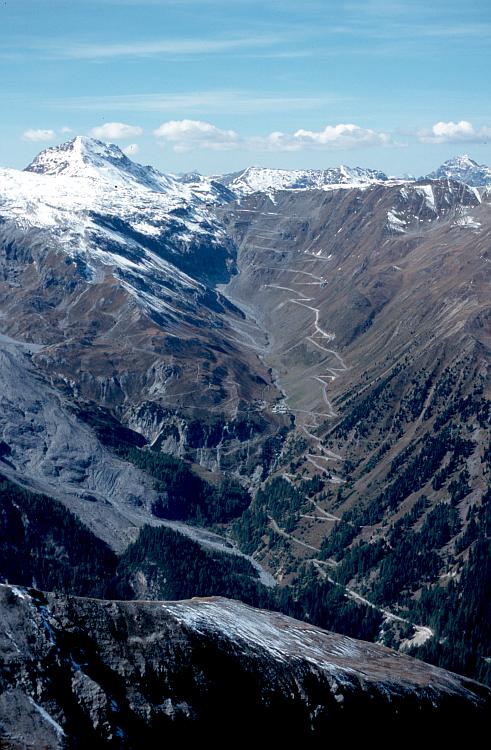
We took a break about halfway up, near the ruins of a burnt-out hotel. We looked further up the pass and marveled at the engineering of the road, which is cantilevered out over the mountainside in places. Towards the top we found ourselves behind a guy in a pimped-out Ford Focus RS who didn’t seem to possess a very high degree of driving skill.  We followed him into the parking lot at the summit of the pass, where he joined a group of his friends in Mitsubishi Evos and Subaru Impreza WRXs. We stopped again here to soak in the view, looking directly down on a long stretch of the road snaking up the mountainside (photos, above and right).
In a nutshell, the Stelvio Pass is far too narrow to be enjoyed in anything but the smallest of sportscars, and is basically too crowded to be enjoyed at all. Even the SLK felt huge as John lugged it around those tight hairpins. I would strongly advise against driving it on a summer weekend, and if you are going to make the trek to Stelvio, be sure to tour some of the other great passes in the region, which are lesser known but make for far better driving experiences (like the Jaufenpass, Sella Pass, and some of the others I will describe later).
Here is a movie clip that gives you a bit of an idea of what it's like to drive up the Stelvio Pass:
We ran a gauntlet of parked motorcycles at the top of the pass, an area thronged with hordes of bicyclists and tourists, all swarming around a cluster of hotels, restaurants, and souvenir shops.  The crowds disappeared as we descended the other side, into a desolate expanse of jagged mountains. After a few kilometers we reached the turnoff for the Umbrailpass (#10, a.k.a. Giogo di Santa Maria), which was marked by a gate and sign (written only in Italian) that says the road is open from 6 in the morning until 10:00 at night. The Umbrail is one of the only unpaved mountain passes left in the Alps and, at 2500 meters, is the highest pass traversable by car in Switzerland. We crossed the Swiss border (marked only by a deserted customs station) just a few hundred meters down the road, then continued our descent through a barren valley on a challenging road with very few guardrails (photo, above). Apparently far fewer vehicles come down this side and we enjoyed it a lot more than the Stelvio. The road turned to gravel partway down, but it was only unpaved for a few kilometers, perhaps one-third of the total 13.4-kilometer stretch. We were followed by a Land Rover Defender most of the way down – he had no trouble keeping up with us in the gravel – but otherwise we saw more motorcycles than cars on the Umbrail.
We reached the postcard-perfect town of Santa Maria at the bottom of the Umbrail, where we turned left onto the Ofenpassstraße (only in German can one justify the use of the “triple-s”). This took us on a gorgeous route through the Val Müstair, a landscape of dry conifer forests and broad golden meadows that reminded us of western Montana. We stopped at a little restaurant at the top of the Ofenpass (#11, 2149 meters) to buy sodas and candy bars, then hiked a short ways up a rocky trail to sit on a bench, eat our snacks, and enjoy the view. I took the wheel at this point and drove down the other side of the Ofenpass.  The road was perfect – long sweeping bends and minimal traffic. The route took us through a portion of the Swiss National Park (photo, right), home to Europe’s largest Hallimasch fungus (boasting an estimated diameter of 500-800 meters; don't you learn the darndest things on Wikipedia?). The road was dotted with trailheads and the area is obviously extremely popular for hiking. In July 2006, a brown bear was spotted in the park – the first wild bear sighting in Switzerland in over one hundred years. Hikers beware!
At Zernez we turned southwest and took route 27 along the River Inn to the lakeside resort of St. Moritz. We stopped for gas at a BP station that had pumps on both sides of the road. John pumped and paid for the gas while I crossed the street to the store to look for the restrooms. I couldn’t find them so I went inside and asked where the toilets were in German; the young woman at the cash register gave me a strange look and gestured vaguely outside. I circled the whole building but didn’t find a door that seemed to indicate the restroom. I went back inside and asked again. The woman asked me if I was a customer. I pointed to our car and said something that hopefully resembled “that’s our car on the other side of the street”). She pointed to the door and told me the restroom was the first door to the left outside. I went out again, and sure enough, the door was completely unmarked. Strange!
 We had now entered the region of Switzerland known as the Engadin, which means “garden of the Inn” in the local Romansch language. We traversed the Oberengadin or Upper Engadin from Zernez to Maloja, an area marked by a chain of beautiful blue lakes dotted with sailboats and ringed by cheerful hotels. From here we descended the precipitous Malojapass (#12, 1815 meters), our final pass of the day, which would take us back into Italy. This was another very crowded road; we followed a string of cars and motorcycles down an impossibly steep series of switchbacks through thick conifer forest (photo, right). About 22 kilometers later and 1100 meters lower, we crossed into Italy at Castasegna. We noticed a pronounced shift in the local architecture that coincided dramatically with the elevation change: from the high mountains, where the hillsides were dotted with tidy Tirolean chalets with overhanging eaves and window boxes bursting with pink and red geraniums, to the lower valleys, where rambling stucco-walled, tile-roofed villas in warm pastel tones sprouted in haphazard clusters.
From Chiavenna, just inside the Italian border, it was only a short drive south to the shores of Lake Como, where the road suddenly became a busy four-lane highway. The lake was hidden from view most of the way along the eastern shore, as it passes through a series of long and slightly claustrophobic tunnels. Because Lake Como is a very long, narrow lake, we realized that we would have to go ridiculously far out of our way to reach Bellagio by land and it made far more sense to take the ferry from Varenna.  We found the turnoff for Varenna and wound our way slowly down to the lakeshore, following the signs to the ferry. I managed to maneuver the car into what I assumed was the line for the ferry while John went off to scout out tickets. He returned triumphant with a ticket (11,60 Euro for the car and passengers) for the next departure, leaving in about twenty minutes. We walked around near the ferry dock while we waited. Varenna looked beautiful with its brightly-hued villas tumbling down the hill to the water’s edge (photo, right).
A ferry arrived a few minutes later and unloaded; we were about to drive onto it but the man taking the tickets kindly told us it was the wrong one (I think it was the ferry to Menaggio) and ours would be arriving a few minutes later. Finally we got on the right boat and boarded for the fifteen-minute ride across the lake. It was an incredible evening – only a few wisps of clouds in an otherwise brilliant blue sky, and we marveled at the views.  I didn’t have a good image in my mind of Lake Como (other than ritzy villas and resorts, of which it boasts a fair few) before we arrived and I was somewhat surprised by the dramatic mountain slopes of the Parco delle Grigne rising sharply from the east side of the lake. But there was also more development than I expected – the lake is ringed by small towns and the hillsides are dotted with houses. Bellagio, however, was a pleasant surprise – much smaller than I imagined and, dare I say, a bit sleepy even on this gorgeous warm evening at the height of the tourist season. The hotels and houses of Bellagio glowed in a glorious array of gold, apricot, and pink tones as we approached the ferry dock.
Bellagio sits on a point of land that juts into the lake from the south and thus commands some of the most spectacular views in the area. We spotted our hotel, the Metropole, before we reached the dock, and I knew we were in for a treat (photo, above - the Metropole is the pink building to the right of the large white boat). The Metropole is located right on the waterfront and the balconies literally hang over the water (as opposed to some of the other lakefront hotels that have a street in front of them). We drove off the ferry and tried to find parking in a lot in town but it was totally full and, since it was dinnertime, we didn’t expect any spaces to open up soon. We drove a short ways down the road and found another lot with three cars in line waiting to get in. The guy at the gate waved me away but I stayed put and gave him the sweetest look of girlish anxiety that I could muster.  A car left the lot a minute later and the man gestured that I could stay. He came up to my window and said something indecipherable in Italian, but switched to English in response to my blank expression. I told him I wanted to park overnight and he showed me to a spot. It cost 10 Euro, which we figured was fair. We unloaded our bags and hoofed it back to the hotel, which wasn’t too difficult because the SLK’s miniscule trunk (even smaller with the top down) has forced us to travel very light. We walked down a gorgeous flower-bedecked esplanade and I made John stop so I could take pictures as I knew this would be my one and only chance to capture the magical evening light (photo, right).
Our reception at the Metropole was polite if not overly friendly, and we climbed the stairs to our tiny double room on the first floor. The bed took up most of the space but the room was tidy and the gray tile bathroom was clean and serviceable. Our view was exactly as advertised – floor-to-ceiling french doors opening onto a tiny balcony with just enough room for two chairs (although ours had only one) and an absolutely stunning 180-degree view of the lake (photo, below, with a car ferry like the one we took from Varenna). Honestly, this was the bargain of our trip at 144 Euro.  We arrived just in time to watch the sun disappear over the mountains to the west, casting long golden rays across the lake. Then we both showered and changed into our best “evening wear” (yes, I brought along my stylish black-and-white sundress especially for this occasion). We strolled along the waterfront looking at menus and decided that the Hotel Florence looked the most promising – it had the most interesting menu and the prettiest terrace overlooking the water, framed by a lovely trellis dripping with wisteria. We had to wait for a while for a table but the waiter we spoke to suggested that we have drinks at their bar across the street. We ordered gin & tonics and sat at a table outside, watching the lights come on across the lake.
We were seated at a table right on the water (the waiter sat us and another couple at the same time but he gave us the better table because we had been waiting longer) and enjoyed an absolutely lovely meal. John had risotto with smoked salmon and caviar followed by roast duck with mushrooms in a balsamic sauce. I started with fresh pasta strips with pesto, pine nuts, and zucchini flowers followed by carpaccio with smoked ricotta and shaved truffle. I don’t think I’ve ever had a plate of carpaccio I didn’t like, but this was a very nice twist on the classic. We asked one of our servers for a wine recommendation and he suggested a very nice Barbera red that had a whole long story associated with it (I think he knew the family or something – it may have all been made up, but he told the story with great enthusiasm!). For dessert we both had peach and white chocolate mousse with a milk-based sauce flavored with cognac and almond. We teetered back to the hotel (thank goodness it was only a few hundred yards away) and fell into bed.
More photos from today's drive:
http://www.flickr.com/photos/hausfrau/sets/72157602870675228/
 We got going around 10 am and I drove us to Lauterbrunnen, where we bought tickets for the 11:30 train to Kleine Scheidegg. (It is very expensive to go all the way up to the Jungfraujoch, so don’t do it unless you know you will have good weather at the top!) We were now old hats at all this, having done the identical journey up to Kleine Scheidegg with my parents last fall, and we settled into our compartment on the cog train for the 45-minute ride up from Lauterbrunnen and through Wengen (view from the train, left). The train was quite full; we sat across from a couple of British guys and an American family with two teenagers. The mountains were totally clear on the way up and we agreed that it could not have been a more perfect day for this journey. We saw a few of my favorite Swiss cows along the way, wearing their characteristic bells (remember this detail for tomorrow, too). We had a short wait at Kleine Scheidegg so we went into a gift shop and bought some magnets (I recently started collecting magnets from all of the countries we’ve visited since we’ve been in
  reason, a small herd of goats had camped out right in the middle of the train station and were eliciting lots of attention from the Japanese tourists.
  The Jungfraujoch station is an enormous multi-level complex, most of which is built inside the rock itself (see photo, left). (Here is a good picture of the complex: http://en.wikipedia.org/wiki/Image:Siteoverview.jpg) We stepped off the train into what felt like a cross between a subway station and an amusement park, with an array of colored arrows pointing the way to the various attractions. We first walked through the
  (the mother from the family we were sitting next to on the train took our picture for us). Then we took the high-speed elevator up to the Sphinx (it climbs over 100 feet in a matter of seconds), where you can walk around outside on a circular viewing platform. From here we got incredible panoramic views of the mountains and the awesome Aletsch Glacier, which, at 120 square kilometers, is the largest glacier in the
  Finally the hütte came into view – a rugged-looking structure on stilts, clinging to the “hip” of the Mönch. Below us we could see a climbers’ camp consisting of a snug circle of dome tents clustered in a not-so-sheltered hollow and agreed that we would leave snow camping to the die-hard mountain climbers.
  We literally ran, slipping and sliding through the snow, all the way back, and arrived at the station at 4:40. Clouds were starting to move in over the
  We arrived back in Lauterbrunnen (photo from the descent, left) at 7:30 and then made the 45-minute drive back to Kandersteg without incident. We had dinner at the Hotel Victoria across the street, where we were served by a very nice waitress from


